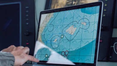
SpacePort Using Geospatial Data To face Transport Challenges In Ports
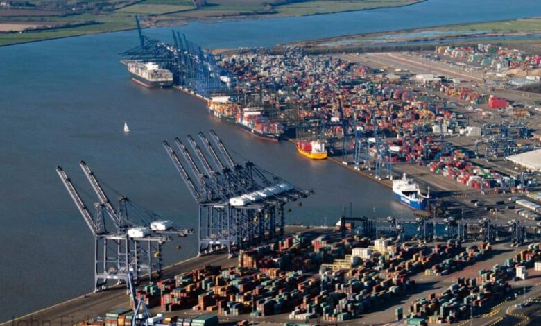
UK’s ports are a vital part of the country’s supply-chain logistics infrastructure
The UK’s ports are a vital part of the country’s supply-chain logistics infrastructure. However, they can also be pinch-points, which can cause congestion and contribute to poor air quality.
The SpacePort project, funded by the Geospatial Commission and Innovate UK, will explore how novel geospatial systems can streamline port operations, improving efficiency and tackling societal disbenefits.
Connected Places Catapult
SpacePort brings together marine sector specialist Marine South East, Connected Places Catapult who have deep experience in supply chain logistics, and Portsmouth International Port, the UK’s largest and most successful municipal port.

Portsmouth International Port
Portsmouth International Port has ambitious plans to boost both passenger numbers and freight volumes in the next decade but wants to do this sustainably and without contributing to the city’s air quality issue.
Advanced information systems can offer potential solutions to the challenges of congestion and low vehicle capacity utilisation. They can be used to allow freight (from full containers down to individual consignments) to be tracked and processed seamlessly which allows vehicles to be operated more efficiently.
Portsmouth City Council is proposing to create consolidation centres which would allow freight movements to be optimised, and to move containers from the port to outside the city with zero emissions. These centres need to be fully integrated into the wider maritime logistics network.
A pilot system
The SpacePort project aims to explore the feasibility of a pilot system to achieve this integration. Marine South East will work with Connected Places Catapult to research and develop a solution to this challenge based around smart application of geospatial data resources. The project will develop advanced information services to streamline supply chain logistics from the port to the city and hinterland, offering increased customer value-add whilst minimising congestion and air pollution.
The project will work closely with Portsmouth International Port and Portsmouth City Council, to ensure that the solutions meet the needs of the port and its customers, align with the city’s transport strategy and port masterplan whilst also delivering significant improvements to the air quality of the city.
Small Business Research Initiative

Commenting on the project, Jonathan Williams, CEO of Marine South East, “The UK economy depends on its ports, importing vital supplies and delivering exports to customers. Yet ports can also be bottlenecks, causing delays and contributing significantly to traffic congestion and emissions in port cities. MSE are delighted to be working with our partners Portsmouth International Port and Connected Places Catapult to find novel solutions to these challenges, exploiting the power of geospatial data and analytics. These solutions can also be pathfinders for other UK ports, leading to the development of high value information services for the international port logistics market.”
SpacePort is funded by the Geospatial Commission in partnership with Innovate UK under SBRI (Small Business Research Initiative). The project secured funding from a £2m transport location data competition which looks at how location data can spark innovation and support the future of mobility for the United Kingdom. The project is 3 months in duration.
press release